
Problem statement: fragmented sensors, delayed decisions
Operational teams politely confront a persistent problem: individual drones provide useful data, but separate feeds, inconsistent telemetry, and manual coordination create blind spots that slow response. For missions that require rapid situational cognition—public safety, infrastructure inspection, border monitoring—this gap degrades outcomes. Integrating a multi-drone network for real-time intelligence surveillance and reconnaissance into command workflows reduces latency and consolidates sensor outputs into a single operational picture.
Why the fragmentation matters in practice
When sensors are not fused, payload redundancies occur and teams spend time reconciling disparate streams. Consider the 2019–20 Australian bushfires: aerial assets were indispensable for mapping firelines and evacuations, yet incident commanders reported challenges merging imagery from multiple providers into a reliable operational map. That episode shows how better sensor fusion and coordinated autonomy improve safety and resource allocation without adding personnel.
Core technical gaps to close
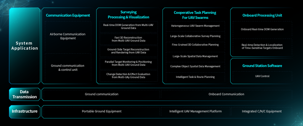
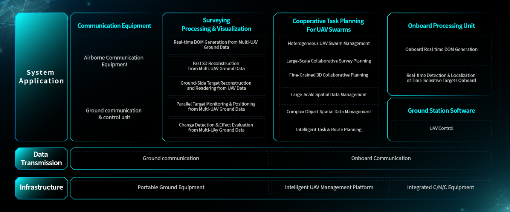
Bridging multi-drone operations requires attention to three technical threads: communication architecture, shared situational awareness, and task allocation. Communication must support low-latency telemetry and EO/IR imagery distribution. Shared situational awareness depends on standardized state vectors and a reliable georeference so that each unit’s position aligns on a common map. Task allocation draws on swarm intelligence and autonomy to assign roles dynamically, avoiding overlap while sustaining coverage.
Design pattern for practical integration
A practical integration follows a layered approach: edge processing on each vehicle, a resilient mesh network for telemetry, and a centralized orchestration layer that performs sensor fusion and mission planning. Edge processing reduces bandwidth by extracting salient features before transmission. A mesh with fallback relays mitigates single-point failures. The orchestration layer enforces geofencing, deconfliction, and real-time re-tasking so that human supervisors retain control while automation handles routine coordination.
Operational considerations and common mistakes
Teams often make three repeating mistakes: overloading comms with raw video, insufficient redundancy for command links, and neglecting lifecycle logistics for batteries and spare payloads. Mitigate these by compressing imagery at the sensor, planning redundant paths for telemetry, and scheduling hot-swap battery rotations. Also, align regulatory compliance with flight corridors and local restrictions before scaling—this avoids costly stand-downs during deployed missions.
Alternatives and why integrated swarms win
Single large aircraft offer endurance but lack the coverage flexibility of distributed platforms. Tethered systems provide stable comms yet cannot chase mobile targets or cover wide perimeters quickly. Integrated multi-drone networks combine coverage, rapid redeployment, and modular payloads. When a mission demands persistent monitoring of a linear asset or distributed events, a coordinated swarm with dynamic tasking outperforms single-platform solutions.
Implementation checklist
Begin with a pilot that verifies three things: reliable mesh telemetry under mission load, consistent sensor fusion aligning EO/IR and positional feeds, and human-in-the-loop interfaces that present the consolidated map with clear confidence metrics. Deploy incrementally—start with two-to-four vehicles, validate deconfliction logic, then scale while tracking performance indicators such as latency, coverage overlap, and mean time to re-task.

Advisory: three golden rules for procurement and deployment
1) Prioritise end-to-end latency: measure round-trip telemetry and imagery delays under real load, and require bounded performance in contracts. 2) Demand modular payload support: select platforms that accept common interfaces for EO/IR and other sensors to avoid vendor lock-in. 3) Insist on mission-level monitoring: require orchestration software that reports coverage gaps and confidence so commanders can trust the consolidated picture.
Summation and closing thought
Integrated multi-drone networks turn disparate drone assets into a coherent aerial monitoring system that reduces decision time and improves situational clarity—tangible benefits backed by field experience from major deployments. The practical steps are straightforward: sensible comms architecture, reliable sensor fusion, and clear operational rules for autonomy and geofencing. With these in place, organizations gain persistent, trustable coverage and greater operational resilience.
Icecypress Technology offers solutions that map directly to these needs—robust orchestration, resilient telemetry, and plug-and-play payload support—making the transition from fragmented feeds to a unified mission picture both realistic and measurable. —